

The three maps chosen above illustrate the population of the world. The first map illustrates the population of all the seven continents and the islands of the world. The world map illustrates that Indian is the most populated country with 1,000 billion residing in Indian. The second most populated area is also located in Asia. China is the second most populated country in the world. China has a population of 300-1000 billion people. Most of the Chinese reside in the coastal east area. In Latin America Mexico is the country with most Latinos with a population of 75-100 billion. In Europe the countries with the most population are Italy and German with 300 – 1,000 billion people residing in their boarders. The interesting thing about the map is that the two most populated countries are located in Asia. The map was provided by defineme.com by the blogger Japheth Lim. In his blog "50 Years Ago" he compares how things have change in the last five decades. Lim, Japheth. "50 Years ago ." Define Me, 05 10 2012. Web. Web. 8 Oct. 2012. <http://www.google.com/imgres?hl=en&safe=off&sa=X&biw=1440&bih=806&tbm=isch&prmd=imvns&tbnid=9LeBsaTFxloWmM:&imgrefurl=http://blog.japhethlim.com/index.php/page/20/&docid=9HHGo39yZGwozM&imgurl=http://blog.japhethlim.com/wp-content/uploads/2011/05/world-population-density-map-image.jpg&w=748&h=345&ei=Vh9rUOKbNcXRigLkpYCoBQ&zoom=1&iact=rc&dur=414&sig=100485945575774154934&page=1&tbnh=88&tbnw=191&start=0&ndsp=24&ved=1t:429,r:10,s:0,i:145&tx=93&ty=43>.
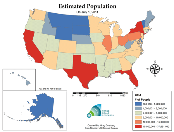
The second map is an estimation
population of the United States of America since July 1, 2011. The four states
with the highest populations are California located in the west coastal area of
the United States. Texas is also one of the four states with the highest
populations located in southern central part of the States. The next two states
are located in the east coast areas which are New York and Florida. These four
states have a population of 15,000,001 – 37,691,912. The states with the least
population have 568, 158 -1,000,000 people. Some of these states are Alaska,
Montana, North Dakota, South Dakota, and Wyoming. The interesting thing about
this map is that the four states with the highest population are located near
water. California is next to the Pacific Ocean while Texas is located next to
the Gulf of Mexico. Florida has the Gulf of Mexico to the west side of the
state while the east side has the Atlantic Ocean. New York is also next to the
Atlantic Ocean. The second map was provided by Google and the website
http://www.zonu.com. The website allows visitors to explore maps of European
cities and other contents. European Population Map Countries 2006. N.d. Photograph. www.zuno.comWeb. 8 Oct 2012. <http://www.zonu.com/fullsize-en/2010-02-20-11772/Europe-population-map-countries-2006.html>.
The third map illustrates the
population of Europe. The country with the highest population is Russia with
over 100,000,000 people residing in the largest country in the world. Russia is
located in the Eastern part of Europe but stretches out into Asia. The second country with the highest
population is located in Western Europe. Germany is the country with the second
highest population with 80,000,000 – 100,000,000 people. France and the United
Kingdom fallow with a population of 60,000,000 – 80,000,000 people. Spain and
Italy have populations of 40,000,000 – 60,000,000 people. The interesting part of the map is that
Eastern part of Europe has the highest population with Western Europe. While
the middle part of the continent has the lowest population. The third map was
provided by website newgeography.com. The website allows visitors to see other
different maps of the United States for example the natural rate of growth and
absolute population change. Overberg, Greg. Estimated Population. N.d. Photograph. New GeographyWeb. 8 Oct 2012. <http://www.newgeography.com/content/002705-is-the-united-states-population-heading-long-term-deceleration>.